Home |
View Cart |
About ZCM |
Contact Us |
Help |
1.888.434.MAPS (6277) |
Sales@ZIPCodeMaps.com
Most Popular Maps
Zip Code Maps
Carrier Route Maps
Radius Maps
State Maps
County Maps
Street/Road Maps
Demographic Maps
Census Maps
Reference Maps
Most Popular Mapping Data
Zip Codes
Carrier Routes
Road Networks
Postal Bundle
Political Bundle
Census Bundle
Mailing Lists
Demographics
ZCM Interactive
Mapping
Postal Information
Maps
...by Postal Geography
5 Digit Zip Code Maps
Carrier Route Maps
ZIP+4 Maps
3 Digit Zip Code Maps
SCF Maps
...by Area they Cover
State Maps
County Maps
Custom Area Maps
Metro Area Maps
City Maps
State Sectional Maps
USA Maps
US Regional Maps
MSA/CBSA Maps
Single- & Multiple-Zip Code Maps
...by Type & Purpose
Street Maps
Census Maps
Reference Maps
Sales Terrritory Maps
Store Locator Maps
Delivery Maps
Site Location Maps
Customer Density Maps
Target Marketing Maps
Market Area Maps
Pizza Delivery Maps
Custom Maps
Custom Radius Maps
Custom Area Maps
Custom Data Maps
Mapping Data
... by Postal Geography
5 Digit Zip Code Maps
Carrier Route Maps
ZIP+4 Maps
3 Digit Zip Code Maps
SCF Maps
Street/Road Network
Postal Bundles
... by Geography Covered
USA
US Regions
State and Multiple States
County and Multilple Counties
City
Metro
Custom Area
Base Mapping Data Bundles
Postal Geography
Political Geography
Census Geography
Street/Road Network
Data
Demographics
Postal Data
Lists
Mailing Lists & Enhancements
Software
Mapping Software
Mailing Software
Mapping Services
Custom Mapping
Custom Data Services
Sales Territory Design
Site Selection/Evaluation
Web Applications
Custom Web Application
Franchise Territory Management
Direct Mail Management
Target Marketing
Sales Territory Management
Resellers & Preferred Customers
Press Center
Career Opportunities
Other great sites:
Postal Bundles of Mapping Data
The Best Postal Mapping Data Available
*
Updated Monthly
*
CASS Certification Compatible
*
Available for use with ESRI, MapInfo and other mapping software
*
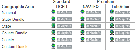
Compatible with TIGER, NAVTEQ, and TeleAtlas street/road data
*
Available in Standard and Premium Versions
What Postal Mapping Data can you get:
*
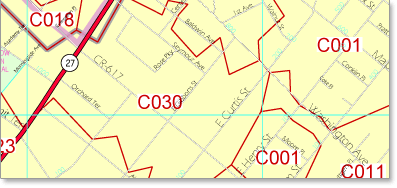
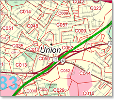
Zip Code, ZIP+4, Carrier Route Boundaries and Data
*
Choose National, State Bundle, State, County Bundle, County, Custom Bundle
*
Choose Monthly, Quarterly, Semi-Annual and Annual Updates
*
Choose ESRI, MapInfo and Database Formats
Postal Bundles Available:
Standard
Premium
Geographic Area
TIGER
NAVTEQ
TeleAtlas
National
State Bundle
State
County Bundle
County
Custom Bundle
Accurate, Up-to-Date Postal Mapping data for as little as
$156.20....as low as $2,550 for National Coverage!
Receive your mapping Data
as fast as the same day!
Call or
email
us Today!
1.888.434.MAPS
What Other Mapping Data Products can you get:
*
Custom 5 Digit Zip Code Boundaries and Data
*
5 Digit Zip Code Boundaries and Data
*
Carrier Route Boundaries and Data
*
ZIP+4 Centroids/Latitude and Longitude
and Data
*
3 Digit ZIP Code Boundaries and Data
*
SCF Boundaries and Data
*
Census Boundaries and Data
*
Political Boundaries and Data
*
Custom Sales Territory Boundaries and Data
*
Street/Road Network Data
*
Demographic Data
*
and much more...Ask Us!
Home
|
Help
|
Site Index
|
Return Policy
|
Reseller Program
|
Affiliate Program
|
Contact ZCM
©Copyright . Intelligent Direct Inc.
10 First St. Wellsboro, PA 16901